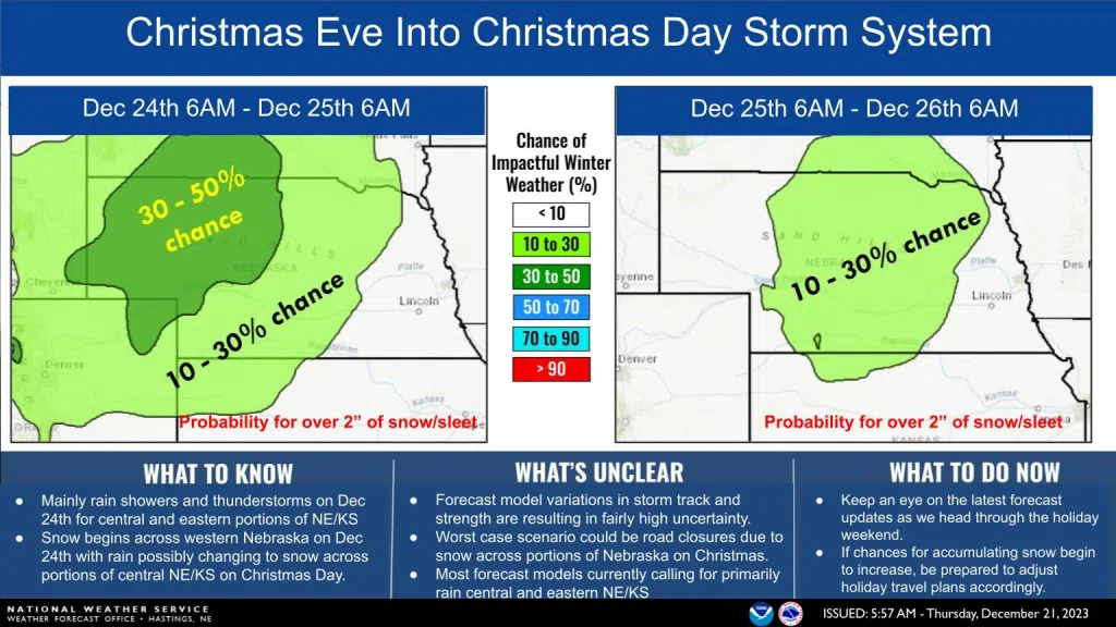
KEARNEY — There is a potential for impactful weather for the upcoming Christmas holiday. There are rain and thunderstorm chances expected on Christmas Eve, rain could change over to snow, and this could cause significant travel impacts.
The upcoming weather forecast is complex, as two systems will be phasing together over the Rockies and how that evolves will determine how conditions develop, per the National Weather Service – Hastings.
The first wave of precipitation associated with a lead vorticity maximum will swing north-northeast ahead of the main system on Saturday into Saturday evening. There is a 20 percent chance across the far west-southeastern areas of the NWS Hastings zone during the afternoon hours.
The main push of the system will take place Saturday night into Sunday, Christmas Eve, and the forecast has widespread 80-90 percent chances of precipitation. Models continue to show the potential for isolated to scattered thunderstorms Saturday night into Sunday.
Moving into Christmas Eve and Christmas Day, there remains uncertainty regarding the strength, track and timing of the main system, which leaves questions about potential temperature and a possible switch over to more wintry weather.
NWS Hastings’ current thinking is that there will be the first push of precipitation, followed by a lull in activity. A second round could arrive in the Sunday night into Monday, Christmas Day, timeframe.
“Colder air will push into western portions of the area at some point, but confidence in exactly when and how far east it that gets is in question,” NWS Hastings states.
Rain could change to snow on Monday, but this is no guarantee, according to NWS Hastings.
Models show differences with some favoring more snow accumulation northwest of the Tri-Cities, while others show snow reaching along or west of Highway 183.
If the upcoming model’s trend toward the latter case, the threat of winter weather and travel issues could be more of a concern Christmas Day into Tuesday, as it shows a more organized upper-level low with a more favorable track and more precipitation over the area.
Those with travel plans, especially on Sunday night, should pay close attention to the forecast.