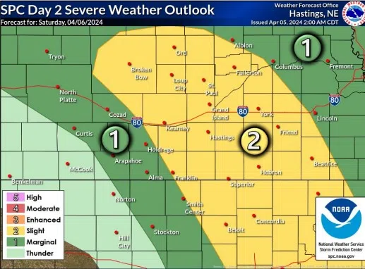
HASTINGS — Severe thunderstorms, strong winds and potentially critical fire weather conditions are possible across the area this weekend.
The Storm Prediction Center in Norman, Okla., has included the Tri-Cities and areas northwest and southeast into Kansas in a Slight Risk for thunderstorms, a two out of five threat.
This is due to a strong upper-level system that is approaching the area from the west on Saturday. A surface pressure gradient will increase and lead to wind gusts of 50 to 60 mph by the afternoon, per the National Weather Service – Hastings.
A High Wind Watch will go into effect for all central Nebraska Saturday afternoon into the evening. South and southwest winds be 35 to 45 mph. The wind will then shift out of the northwest later in the day.
Damaging winds could blow unsecured objects and cause tree damage, travel could be difficult, especially for high profile vehicles, according to NWS Hastings.
An arch of strong to severe thunderstorms during the mid to late afternoon hours is expected. Overall instability is on the lower side due to the lack of high-quality moisture, but strong forcing and high wind sear should contribute to severe storms along the front.
Once the front moves through, models are showing a few hours of low dewpoints, especially near the Nebraska-Kansas border and north central Kansas with relative humidity in the single digits.
This will contribute to near critical fire weather conditions and a fire weather watch may be issued.
After a busy weather weekend, the start of the next work week looks far more calm, with near to slightly above normal temperatures and only a small chance for light rain showers on Tuesday and Wednesday.