
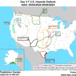
Active weather will continue for the remainder of the week across the nation’s mid-section, as pulses of energy arriving from the western U.S. will spark heavy showers and locally severe thunderstorms. Five-day rainfall totals should reach 1 to 3 inches or more from the central and southern Plains into the middle and lower Mississippi Valley, with the hazards of high winds, large hail, and isolated tornadoes partially offset by the benefit of rain falling in remaining drought areas of the western Corn Belt and the central and southern Plains. Late in the week and during the weekend, showers will spread into the eastern U.S., although most areas will receive rainfall totaling an inch or less. Elsewhere, frequent showers will dot the northern half of the western U.S., while mostly dry weather will prevail from southern California to the southern Rockies.
Brownfield Ag Weather Today

Central Nebraska Today News
See More


