NEBRASKA-KANSAS STATE LINE — There is a scene in the 1996 film “Twister” when Bill Paxton’s character is standing outside observing the changing clouds and the ominous strings begin to play. Another character approaches and he simply says “Goin’ Green.”
What Paxton’s character is referenced is exactly what I got to see along the Nebraska-Kansas state line on Monday, May 6.
As the morning of the first work day of the week wore on, I found myself in a dilemma when it came to target selection. The Storm Prediction Center had issued a rare High Risk across northern Oklahoma for the threat of strong, long tracking tornadoes.
The last time a High Risk was issued in Oklahoma was 2019. It has been a bucket list item of mine to chase in Oklahoma some day, some of the strongest tornadoes to ever impact the United States have hit the state.
On Sunday night, I was mentally committed to the six hour drive, the forecast for strong tornadoes seemed like a sure bet. But on Monday morning, I had a crisis, because severe weather was threatening south central Nebraska as well.
So I could go south with a seemingly guarantee to see tornadoes, but what if I missed something that impacted my home state in an area I cover for the news?
Eventually, a combination of feeling responsible for the coverage area and dreading a six hour drive home in the dark and minimal sleep for the next work day persuaded me to stay local.
Looking at the forecast, wind vectors aloft were more parallel to the dryline boundary and this would promote a line of storms over discrete cells. There still looked to be a favorable amount of wind shear, even early in the day.
Storms looked to fire in north central Kansas and then track into south central Nebraska.
After a weather briefing from the National Weather Service – Hastings, I hit the road and decided to target Alma along the state line to wait for storms that were already developing at 10:30 a.m.
I actually drove into Kansas for a better look, but it was clear I had to get back into Nebraska and headed west toward Beaver City to cut off the most promising area of the thunderstorm complex.
It’s not out of the question that circulations or embedded supercells can develop along these lines of thunderstorms. Tornadoes can often occur within these features. In fact there had been damaging tornadoes that took place across southern Nebraska during the evening of Friday, May 3.
As the storm approached by location, visually it looked promising. There was low hanging scud along the forward flank and a rear flank downdraft seemed to be developing. I had to retreat back east as the heaviest rain began to arrive.
As I headed back to the highway to keep following the storm north, there was an issue. The low clouds I had noted earlier had not burned off and this led to a stable air mass in the I-80 corridor.
As soon as storms entered into this area, they began to fall apart and weaken significantly. I considered this and then took a look at the radar and decided to just keep working my way down the line of storms and waiting for promising areas of potential circulation.
I headed over to Republican City, north of the Harlan County Reservoir, for a better view of what was approaching. It was clear storms down in north central Kansas were working in a more unstable air mass and had the potential to strengthen.
With the Nebraska sector looking like it wouldn’t get anything done. I decided to jog down into Kansas to await the tail end of the line.
However, I was having a frustrating time sticking with a target. As soon as I would want to stay north, something to the south would look more interesting. Then when I was heading south, the northern target would light back up with a severe thunderstorm warning.
Doing this kind of flip flopping is a great way to miss out on everything.
I finally told myself my news coverage responsibility was in Nebraska so I headed back north and arrived in Franklin just as a looming shelf cloud from the edge of the thunderstorm complex was nearing the edge of town.
I headed east toward Riverton to put some distance between myself and the heavier rain. Almost by accident, another area that appeared to have weak circulation was developing to the southeast and headed in my direction.
It felt better to finally be committed to a new target and I kept backing away from the line as necessary.
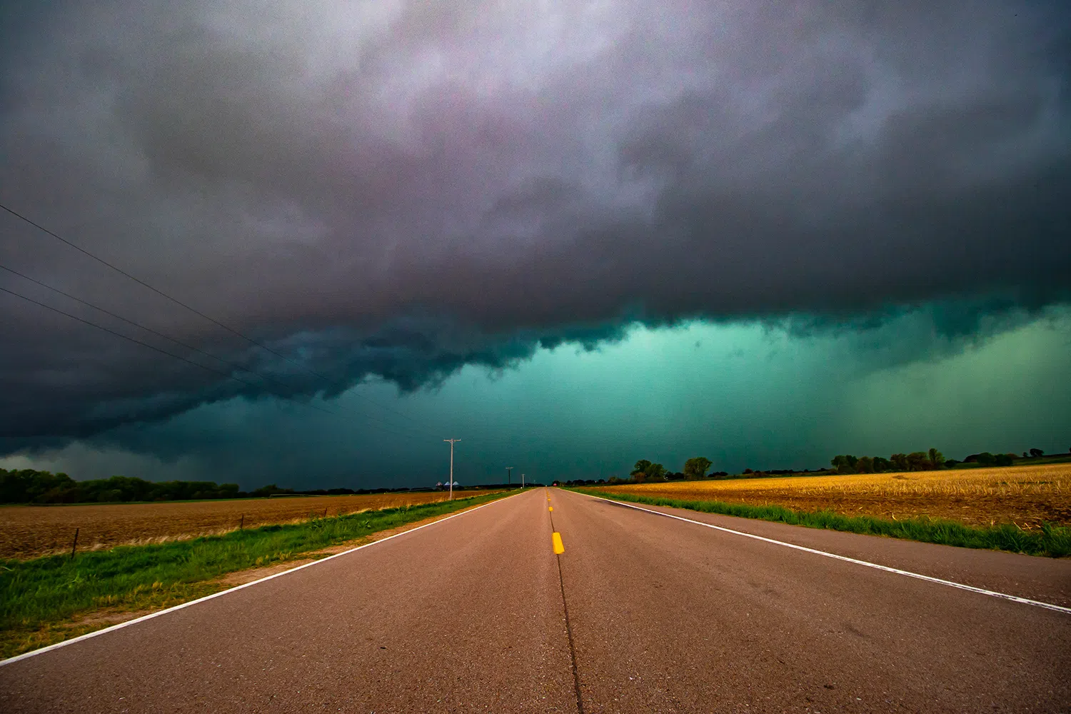
It was while letting the edge of the thunderstorm approach as close as I dared, that the quote from Twister sprang to my mind.
The afternoon sunlight was striking the back of the precipitation core, containing rain and large hail. As an effect, the whole area turned a dark shade of green.
Thunderstorms with heavy precipitation can be strongly illuminated from behind by reddish sunlight, such as at sunset. The high water content of the cloud absorbs red light, resulting in a green colouration.
It has often been said that green clouds mean a tornado is close behind, but this usually is not the case. Hail production does occur with supercells and other storms that generate tornadoes, but the environments that produce the strongest hail storms are often not conducive to tornado development.
This might have been the strongest shade of green I have witnessed in a thunderstorm and I was happily snapping away with my cameras when the storm’s outflow passed my location.
I was struck by how cold it was, but given the rain and hail cooled air it contained, I wasn’t too surprised.
I had finally retreated to the west of Red Cloud when I considered calling the chase. I had been on the road from 10 a.m. to 4 p.m. and no area of the storms had been able to get enough rotation together for a tornado.
With some decent shelf cloud and green hail core photos in the bag, I decided to punch through the thinnest part of the squall line, avoiding the hail as it passed to my north. Luckily all I encountered was some heavier rain and I could soon see blue sky on the other side.
However, Mother Nature continues to be a fickle mistress. No more than a few minutes after I decided to bail from the storm. A tornado warning was issued for Webster County with Lawrence being in the red polygon.
Edit: An EF-0 tornado would occur near Cowles, not far from where I decided to call the chase. It is frustrating that I called the chase right before the tornado would occur, I would have been in the area to intercept. However, there was little chance that I would have seen it, given that it was wrapped in rain most of its life.
Breaking free and arriving on the backside of the storm, I was amazed at the mammatus cloud display on the underside of the storm’s anvil cloud.
The distinct “lumpy” undersides are formed by cold air sinking down to form the pockets contrary to the puffs of clouds rising through the convection of warm air.
There were also cloud streaks that created a remarkable pattern as I arrived back home around 5 p.m. Ironically, some of the most distinct and aesthetically pleasing shots I took were just outside of my house.
It just goes to show that you can make all the predictions and forecasts in the world, but Mother Nature always has a way of humbling you.
Regarding the High Risk in Oklahoma that I decided against pursuing, in the end I was glad I had stayed locally. There were few in the way of photogenic tornadoes and there would be damaging tornadoes that would impact communities north of Tulsa after dark.
Had the Oklahoma storms fired farther to the southwest in the state and tracked into better low level instability, then I have no doubt there would have been yet another tornado outbreak this season.
The Monday, May 6 set up seemed to underperform in some ways, but for all the people that could have been potentially impacted by more severe weather, that is a blessing.
A southern Plains storm chase is still on my bucket list, but May 6 was a good reminder that sometimes staying close to your home area yields results that are interesting in their own way.
Editor’s Note: My name is Brian Neben and this is my sixth year as storm spotter and chaser. I write a personal column about each outing, as it helps to collect my thoughts and I have felt like people enjoy reading about my success or failures perusing this rather niche hobby.