CUSTER CO. — I have a love/hate relationship with Custer County as a storm chaser.
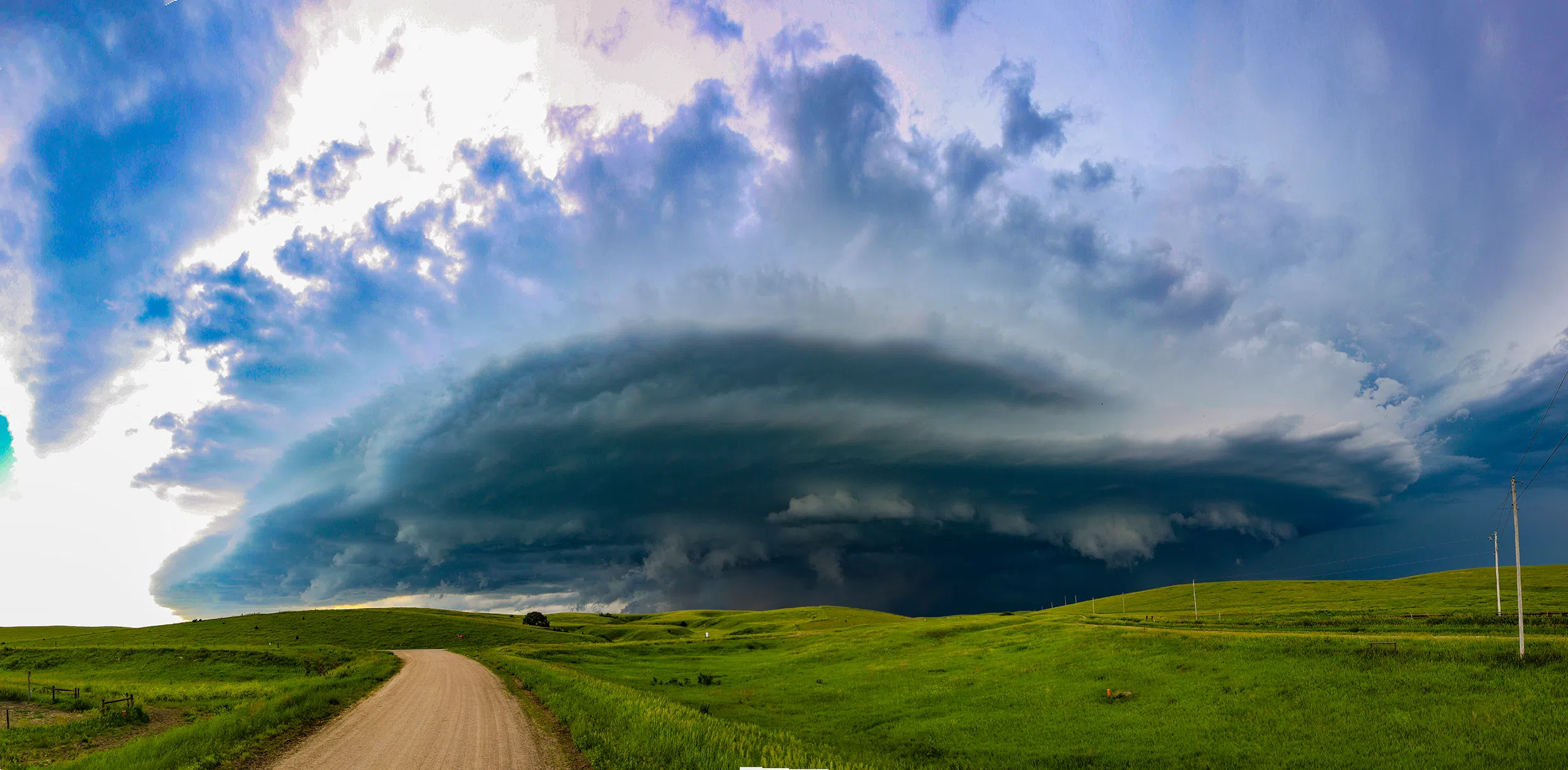
On one hand, the pastures of this north central Nebraska county in early June are a vibrant green that I can scarce describe and the rolling hills provide a near perfect foreground for storm photography.
On the other hand, it is a rural county, likely home to more cattle and people and the road options through those green hills are noticeably few and far between.
I got to relearn why I love and hate chasing in the area on Friday, June 7.
The Storm Prediction Center had placed a good swath of eastern Nebraska under an Enhanced Risk for severe weather this day with north central and south central Nebraska still under a slight risk.
A shortwave disturbance would be rounding the top of a ridge of high pressure that was building into the Plains. Being early June, moisture quality was not a concern – so storms would have ample fuel and the wind shear looked to be favorable for supercells.
This type of pattern promotes storms that move from northwest to southeast, backwards from the more usual track of southwest to northeast.
Ironically, nearly two years to the day I had chased a setup that was nearly identical across nearly the same area. History doesn’t repeat, but it does rhyme.
Storms were set to fire across the Sandhills in the early afternoon hours before they began propagating to the southeast. Just like in 2022, I held my ground, taking care of my usual Friday errands, and watching which storms would become dominant.
After a little hemming and hawing because of a left moving storm that could have spoiled things, my partner Emaly finally just told me to go for it and come what may. With her push and a recent mesoscale discussion from the SPC that noted prolonged supercells – I hit the road.
I was going to be faced with a choice due to the lack of paved roads.
When I got to Miller I could continue on up to Ansley and wait for the storms to head in my direction, or take Highway 40 over to Oconto and then approach the storms directly from the south but risk being out of position if their forward speed increased.
My gut told me to approach directly from the south and that hunch paid off. The initial supercell I had targeted was being absorbed into the forward flank of a larger supercell to its west and its forward speed was only 25 to 30 mph.
As I hit Highway 21 and headed north, I was able to view storm structure through gaps in the hills and what little I was teased with looked impressive.
Finally getting within close distance, I found a spot to turn off the road and was delighted to find it was part of an old section of Highway 21. It was a flat foreground for photos, with enough space to turn the car around in a hurry.
The sight to my northeast was astonishing – an approaching supercell with wind sculpted structure that was highly visible. Tornadoes are usually the main target of most storm chasers, but lacking those, most will take a structure show as a close second.
I was able to hold my ground for a while and put my new wide angle lens through its paces as the supercell approached. The amount of air being sucked into the storm was notable, with a long line of dust at point acting as a tracer for a region of strong inflow.
Finally, rising dust in the field to my immediate north marked the approach of the rear flank gust front and I had to retreat a few miles to the south to avoid this region of the storm.
I wanted to keep up with this supercell as it showed no signs of weakening, but the lack of road options was going to make this a challenge. I typically try to avoid gravel roads as they can be in various states of maintenance and, once rained on, can turn into bad places for a low riding car to be.
But if you want to navigate rural Custer County, the gravel roads are your only option, so I made my way to Pressy East Road and eventually Buckeye Road. My idea was to use these to reach south of Mason City.
The plan worked well at first, I was able to keep up with the RFD surges of the storm as it continued on its track. Eventually, a tornado warning was issued for noted mid-level rotation, but from my vantage point I didn’t see anything and as of writing , no tornado has been confirmed.
I made it across old Highway 183 and finally found a spot to stop south of Mason City and grabbed more photographs of the looming supercell which was rapidly approaching my location.
It was clear I was going to have to get farther south if I wanted to avoid tangling with the RFD and the hail filled precipitation core. And this is where the lack of road options can become dangerous.
Unlike the roads on the grid system in more populated areas, there might not be a turn south at the next mile or for several miles. The roads in cattle country can meander around in several directions and not always the way you want to go or just terminate into prairie oblivion.
I found a path that could get me out of the way of the way, and not a moment too soon. The approaching RFD surge was getting too close for comfort – marked by the lofted dust in the field right next to me.
Trouble began when I was on 335th Road, having entered Buffalo County, with the looming precipitation core to my north approaching. I made a poor choice of a road south when the initial road turned into a rough looking minimum maintenance road.
My dilemma was to risk the poorly maintained road, or double back to 335th and retreat to the west – but the rain would be pouring on the gravel road. I made the choice to head back west, away from the storm, hoping to punch my way out of the precipitation core.
While heading west as fast as I could, I was enveloped in a heavy rain curtain and my visibility dropped. What happened next was a good reminder of why I am a driver first and a chaser second.
At the moment I crested a blind hill I found myself face-to-face with another chaser headed east and we were both in the middle of the road trying to avoid the edges.
I pulled hard to the right to get out of the way and the back of the car fishtailed on me for a moment before I was able to get it under control. For a second I thought I might end up in the ditch.
The encounter could have ended far worse and it was a good reminder that driving is still the biggest risk when it comes to storm chasing.
By this time I had fallen off the pace and the rear flank of the supercell was over the Pleasanton area. I watched it depart and normally that would have been the end of the chase for me.
However, I had noticed on radar that a second supercell had formed to the northwest of the current storm I was on and looked to be showing all the signs of a maturing cell.
There was also a third severe warned thunderstorm farther west that I could tell would impact my home in Odessa if it kept on its current course.
I headed back west to get down stream of the cell as it approached the Amherst area. It was likely due to the fading light, but this cell just had a mean look about it.
I paused near Highway 40 to get several photos, but what would be a hallmark for this supercell, its rear flank downdraft surges would be fast. I had to reposition quickly several times trying to stay downstream of this cell.
Eventually, I reached the edge of the Kearney city limits and would have to navigate through town if I wanted to stay ahead of the precipitation core.
Chasing locally does have its benefits, I could tell the other out of state storm chasers were taking 11th St. over to Second Ave. to go south. To avoid the traffic, I jumped off at Yanney Ave. and took the recently extended Talmage St. over to Second Ave., which I felt was a savvy move.
I drove south over the Platte River and found a place to turn around to face my pursuer, the rear flank of the storm was passing directly over Kearney and there was scattered damage throughout the town, as I would later find out.
The blue-green hue of the core was striking as the sun began to set.
I couldn’t stay long because the line of supercells was beginning to merge into a greater storm complex and the western edge of that would pass over my home.
It’s a personal pledge to myself that no matter what, if a severe storm is going to impact my home, I need to be with my partner, Emaly. I don’t want her to have to ride out a potentially damaging storm by herself.
It was going to be a close shave though, to get from south of Kearney to Odessa, I was just barely going to beat the main core of precipitation that was bearing down on the area.
I headed back west on W Road, or the “River Road,” as my family calls it. I was still in the midst of the Kearney supercell’s precipitation and was surprised to see visible streaks of rain hanging above the fields to my south. The precipitation was that heavy.
I finally broke free of this and was able to make it to Odessa with only a few minutes to spare. It looked like the edge of a waterfall was approaching the town.
Finally inside the house, Emaly and I watched the heaviest rain arrive, punctuated a few times by pea sized hail. It was after the storm had passed that we were able to enjoy its parting gift.
One of my most favored locations to be at sunset is on the backside of a departing storm.
When the sun sets and its light rays strike the underside of thunderstorm clouds, magic can occur. Chasers have dubbed this time ‘golden hour.’
Many people in Dawson and western Buffalo County were able to enjoy the sight of a vivid double rainbow. I stayed out getting additional shots as the storm departed and the sun fully set.
I pulled Emaly out of the house and we were able to enjoy golden hour together. I tend to talk at her about various weather setups, so being able to enjoy a photogenic display with her was hopefully a nice trade off.
Friday’s chase resulted in some of the best supercell structure I have seen all year, but the close call with a potential head on collision was a timely reminder that the storm isn’t the only dangerous part of chasing.
As for Custer County, my love/hate relationship continues with the area.
I don’t think the Custer County Commissioners would see the humor if I showed up to their next meeting demanding more paved roads through the region for the express purpose of storm chasing.
Until then I will follow John Denver’s lead and continue to rely on the good ol’ country roads.
Editor’s Note: My name is Brian Neben and this is my sixth year as storm spotter and chaser. I write a personal column about each outing, as it helps to collect my thoughts and I have felt like people enjoy reading about my success or failures perusing this rather niche hobby.
Custer-Buffalo County Supercells
Golden Hour on June 7, 2024


