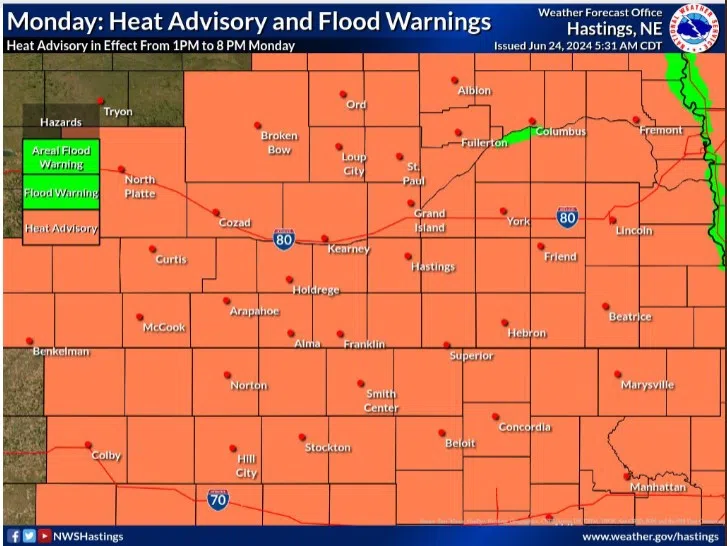
Heat Advisory for Monday, June 24, (National Weather Service - Hastings, Courtesy)
HASTINGS — A Heat Advisory is in effect for the entire central Nebraska region today as heat index values will reach 105 degrees.
According to the National Weather Service – Hastings, Monday will be the warmest day of the week as highs climb into the upper 90s and low 100s. The heat index value will top out around 105 degrees for most locations.
The Heat Advisory will be in effect from 1 p.m. to 8 p.m.
Those who work or find themselves outside today are encouraged to drink plenty of water or drinks with electrolytes to protect against heatstroke. Take regular breaks inside or in the shade.
Tuesday will be another warm day across the area with a Heat Advisory to be confined along the Nebraska-Kansas border. The advisory will be in effect from 1 p.m. to 7 p.m. The heat index will reach 100 to 105 degrees in these areas.
There is a chance for thunderstorms across the southeastern portions of the area as a cold front moves through.
Wednesday will still be warm, with highs in the mid-80s to low-90s. Dry weather conditions are expected during the daytime hours with storms developing off the western High Plains that will move into the area during the evening.
Starting Friday, an approaching upper-level trough of low pressure will move over the Rockies and will bring additional chances for rain on Friday with continued but lower precipitation chances through the weekend.
Temperatures this weekend look to be cooler behind a cold front passage with highs in the low to mid 80s.