SOUTHERN NEBRASKA — One last chase day before the summer heat shuts down the tornado season for good.
That is how I approached the Slight Risk and five percent chance for tornadoes across southwest and south central Nebraska on Monday, July 1.
Nebraska’s typical severe weather season is at its peak from late May to early June. While tornadoes can happen anytime of year, they get scarce once the upper level ridge builds into the southern United States during the summer.
However, there still can be late season systems that pose a tornado risk. In fact, my best chase day to date came a few days after the summer solstice when I saw five tornadoes on one night in Wyoming and Nebraska on June 23.
Looking at the set up for July 1, an upper-level trough was set to eject over the Plains, with a surface low developing in northeast Colorado. A warm front was set to lift north during the day and would serve as the boundary for which storms would initiate on.
Instability was high, as is common in summer, but wind shear which is usually lacking would be unseasonably strong. It was clear though that storms would grow upscale into clusters or a line, which wouldn’t be conducive to photogenic tornadoes.
Regardless of how storms would develop, a potential tornado chase partially in my backyard was something I was going to take advantage of.
Convective initiation started earlier in far northwestern Kansas than I would have anticipated and I was out the door from work in Kearney by 2:45 p.m. when I saw the first echo tops go up.
My initial target was McCook, as it was clear a cluster of storms was attempting to organize. However, by 4:15 p.m. it was clear I was going to have to jog south at Cambridge to Highway 89.
One of the cells was starting to take on right moving supercell characteristics after it separated from its left split. It looked to move right along the highway.
As I passed through the village of Danbury, I was able to get eyes on recognizable storm structures, such as the rain free base and an inflow tail. The storm even sported a short lived wall cloud before it fell apart and I was forced to head back east.
It seemed after that initial surge, the storm was taking its time organizing again and I made it all the way to north of Oxford before stopping again.
I chatted with another chaser who was based out of Hastings and talked about the active season 2024 had been so far.
Later we were joined by a local resident who lived just down the road. He just looked at us and asked us with a sardonic dryness only a farmer can have, “Are we going to die?”
Life on the Plains has a way of jading most residents to all but the most extreme weather situations.
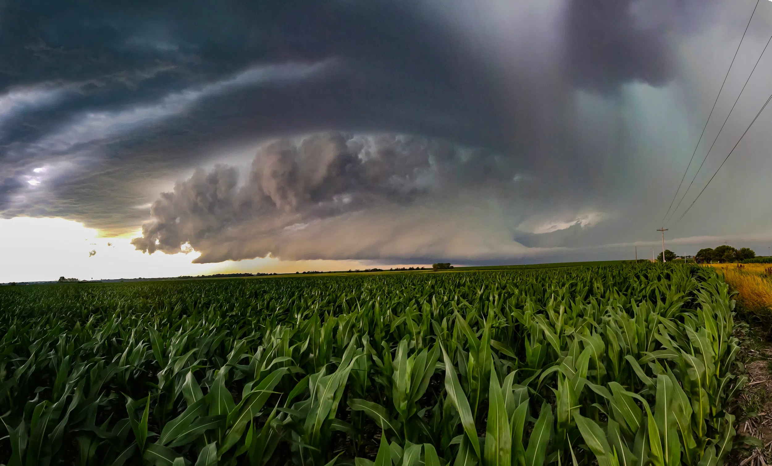
However, the storm had gained a tornado warning and the visual structure had improved markedly. I could see the rear flank gust front and even some curling at the end of it.
The other chaser and I held our ground for as long as we could before the rain from the forward flank began to encroach on our position. I drove over to Highway 4 and found a high perch from which I could watch the advancing storm.
My best pictures of the evening came from this spot with a soybean field providing a contrasting foreground. The rear flank gust front moved steadily from right to left and a persistent tail of inflow kept feeding the storm warm, moist air.
This chase I seemed to be holding my position until the very last moment, but I have gained some confidence in maneuvering around tornado-warned supercells. The key is to always have an escape route in mind and be ready to take it if anything seems off.
After six years of chasing, I have learned to trust my gut instinct.
Just to the west of Ragan, I stopped to watch the cell as it moved over the Atlanta and Holdrege area. Here I got the clearest look at what could have been a tornado, with a tight mesocyclone rotating rapidly, even with a descending base, but from my view, nothing touched down.
The storm was moving persistently to the northeast while a large storm complex was in progress to the north and just behind the supercell. It was clear my storm was going to merge with the line soon.
South of Wilcox I had to head north to keep close to the notch of the storm and I paused by St. Johns Cemetery to watch the roiling motion of the clouds just on the back side of the rear flank gust front.
It was just falling behind the storm, with the rear flank hook out in front of me as I approached Highway 34 and headed west toward Axtell.
There had been reports of stronger mid-level rotation, with possible reports of a brief tornado in Axtell. When I drove through the community, I could see several large tree limbs that had been blown down.
As of writing, the National Weather Service – Hastings was conducting a damage survey in the Beaver City, Holdrege and Axtell areas for possible tornado touchdowns.
If there had been a tornado I was only minutes behind it, but didn’t witness it due to the rain being wrapped around the rear flank of the storm. I have also known the RFD winds to cause damage of their own without a tornado present.
I turned south and came to pause near the Bethany Lutheran Church. I watched the storm continue on for a time before I decided to get back on the highway and continued toward Minden.
By this point the area of rotation had weakened enough that the tornado warning was dropped and it was so wrapped in rain I couldn’t have seen anything from my position. I decided to call the chase and try to make my way home through the heavy rain of the storm complex that was passing through the area.
All in all, I was glad I could get one more decent chase under my belt before the onset of high summer. I have chased this season more than any in the past.
The 2024 severe weather season was notably active and by July, the year has been the second most active tornado season, only behind 2011. There were 400 tornado reports in April and 600 in May.
Chasing as I can between work and home life, I count myself lucky I was able to see two tornadoes this season and on separate days, a first in my chasing hobby.
However, the images of destruction in Elkhorn and Greenfield, Iowa serve as sobering reminders that a more active severe weather season means more people and their property is impacted.
Following the weather serves another purpose for me, it is a reminder that we should take nothing for granted and know that even our best laid plans can be upset in an instant by Mother Nature.
Editor’s Note: My name is Brian Neben and this is my sixth year as storm spotter and chaser. I write a personal column about each outing, as it helps to collect my thoughts and I have felt like people enjoy reading about my success or failures perusing this rather niche hobby.