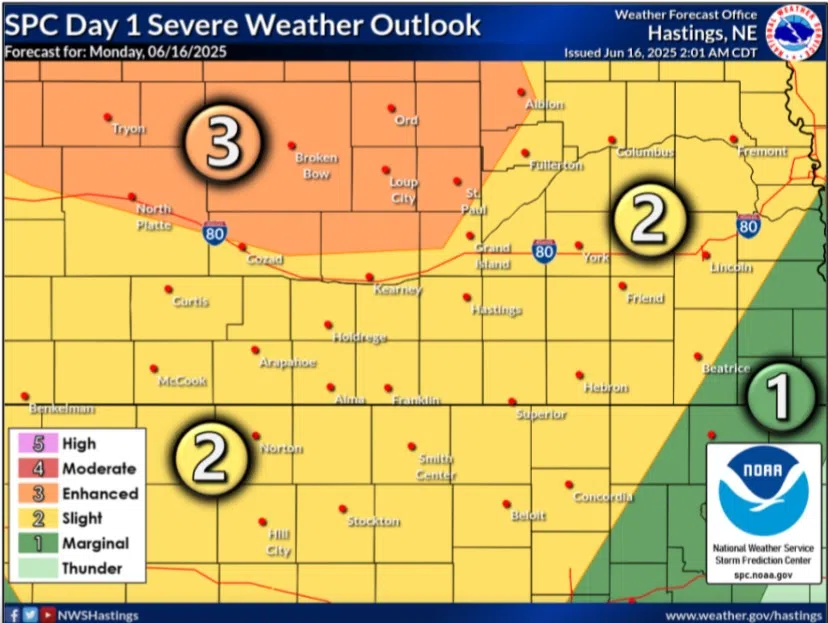
Enhanced and Slight Risks issued for central Nebraska for Monday, June 16, (Brian Neben, Central Nebraska Today)
KEARNEY — An Enhanced Risk for severe weather has been issued across north central Nebraska and a Slight Risk across south central Nebraska for the evening hours of Monday, June 16.
The Storm Prediction Center in Norman, Okla., has issued the Enhanced Risk, a three out of five, mainly for the threat of severe wind gusts and hail up to the size of ping pong balls. An isolated, brief tornado cannot be ruled out.
The threat of storms is due to a low amplitude shortwave disturbance that will track eastward into the area out of the Central High Plains. Modest convergence along several surface boundaries will lead to the development of a low-level jet that will be aimed right central Nebraska, according to the National Weather Service – Hastings.
There are still some questions regarding the exact nature of storm development during the afternoon, but recent model runs hint at storms with supercell characteristics to the north of NWS Hastings warning area along a weak surface front over north central Nebraska.
Additional activity looks to develop to the west over the higher terrain and will start to track to the east. The general expectation is for the storm complexes to merge and then progress east southeastward through much of the area between 9 a.m. and 4 a.m.
The combination of fairly strong instability and sufficient deep layer shear will result in severe weather potential with the main threat being 60-70 mph winds, large hail and a brief spin-up tornado cannot be ruled out but will not be the main threat.
Areas could see up to 1-2 inches of rain, with more local areas seeing 3-4 inches.
The primary severe threat should end for the area by 4 a.m. on Tuesday morning, but trailing convection could still be ongoing around sunrise, especially in the NWS Hastings southern warning area.