
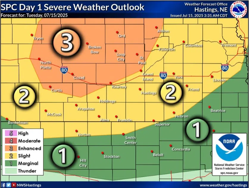
An Enhanced and Slight Risk for severe weather exists across central Nebraska during the evening of Tuesday, July 15, (NWS Hastings, Courtesy)
KEARNEY — An Enhanced Risk for severe weather has been issued for parts of north central and south-central Nebraska for the evening, overnight hours for Tuesday, July 15.
The Storm Prediction Center has issued the Enhanced Risk, a three out of five, mainly for the risk of strong to severe winds, but risk to large hail remains to the northwest of the Tri-Cities and an isolated tornado cannot fully be ruled out in north central Nebraska.
According to the National Weather Service – Hastings, the daytime hours look to remain dry as the first of several upper-level shortwave disturbances begins shifting out of the northern Rockies into the northern Plains. A surface low pressure area will also begin to strengthen over the central High Plains.
This will cause a pressure gradient to strengthen over the region, and this will contribute to southerly winds that will transport more moisture to the region. Dewpoints look to range into the 60s and low 70s across the area.
Late in the afternoon, a surface frontal boundary will begin to enter western and north central Nebraska and will be the focus for thunderstorm development. The environment looks favorable for severe storms, with high instability values.
This initial activity will pose the potential for large hail and damaging winds but an isolated tornado cannot be ruled out. These initial storms are expected to merge into a larger mesoscale convective system and will pose a threat for strong to severe winds as it moves through the region.
This storm complex will also be an efficient rain maker, but its movement should be fairly progressive and notable flooding concerns should be lessened.
Most of the activity should wane or push to the east by 3-4 a.m. with more isolated to scattered precipitation behind the complex.