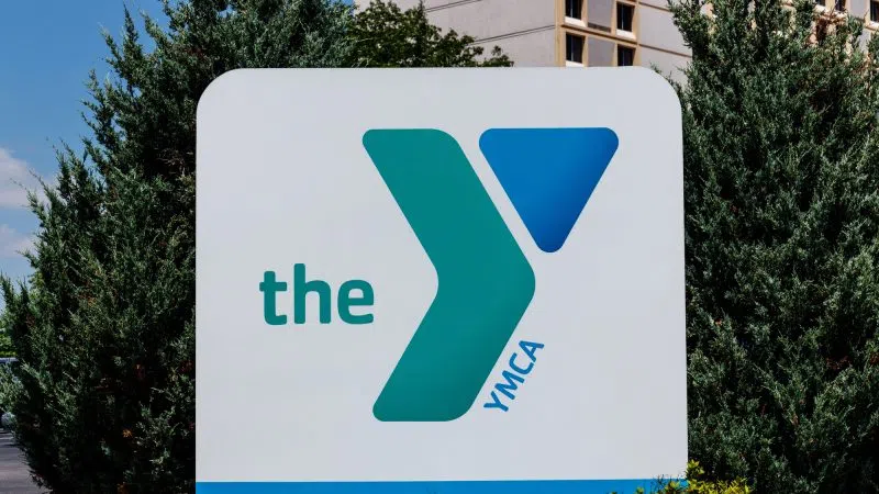

Average date of the first fall frost in central Nebraska, (NWS Hastings, Courtesy)
HASTINGS — It may seem hard to believe given our recent return toward warmer weather, but according to long-term averages, most of the National Weather Service – Hastings forecast area of central Nebraska is already within 2-4 weeks of the average date of the first fall frost/freeze.
Of course, the first fall frost/freeze dates can vary tremendously from one year to the next, and just within the past 30 years, “first freezes,” 32 degrees-or-colder have ranged anywhere from mid-September to early to mid-November, per NWS Hastings.
Last fall actually featured fairly normal dates for the first official freeze in most places, but the first “hard freeze,” 28 degrees-or-colder, was unusually-late, even record-late, for many areas.
Per NWS Hastings, there are no frost or freeze concerns through at least Sept. 25, thanks in part to consistently warmer-than-average temperatures. Overnight lows are unlikely to drop any colder than the 50s for the upcoming evenings.
Last year featured an unusually-late hard/killing freeze for much of our area.
Although most of our forecast area saw a relatively “normal” first official freeze in mid-October, this first freeze was not a true hard/killing freeze, especially for most of our Nebraska forecast area.
In fact, many of the Nebraska counties, including the Tri Cities, did not experience its first official hard freeze until mid-November, which is 3-4 weeks later than average.
It was the latest first hard freeze on record at the following longtime NWS stations and communities like Grand Island, Hastings, Kearney, Holdrege, Gothenburg, Osceola.
Frost
Frost occurs when there is a solid deposition of water vapor from the air. Frost will form when solid surfaces are cooled below the dew point. An air temperature range of 33- 36 degrees, along with light winds, is usually needed to initiate frost formation.
At least minor damage is possible to plants. One must keep in mind that frost is not guaranteed if the air is very dry and if winds are roughly eight miles per hour.
The range of average dates for the FIRST fall frost across most of south-central Nebraska is between Sep. 24 – Oct. 9.
Freeze
Freeze occurs when the temperature drops to 32 degrees or lower. A freeze will damage many unprotected plants, especially if the temperature remains at-or-below freezing for several hours.
The range of average dates for the first fall freeze across most of south-central Nebraska is between Oct. 2 – 17.
Hard Freeze
Hard freeze, per our local NWS definition, occurs when the temperature reaches 28 degrees or lower.
This usually means that most seasonal vegetation will be destroyed. In addition, there is a likelihood of damage to unprotected outdoor plumbing, un-drained sprinkler and irrigation systems etc.
The range of average dates for the FIRST fall hard freeze across most of south-central Nebraska is between Oct. 10 – 27.
Early Frost of 1974
One of the earliest frost or freezes on record in parts of central and south-central Nebraska and north central Kansas occurred the first week of September 1974, as many locations dropped below the freezing mark on Sept. 3.
“An unseasonably cold air mass roared into the region behind a strong cold front. Eventually, surface high pressure set up over the region, creating an ideal situation for a record early freeze. In fact, note the handwritten comment “Record early damaging frosts, corn belt area” at the top of the weather map,” per NWS Hastings.
The Gothenburg site observer noted on their form, “Clear. Froze. Ice. Crop Damage.”