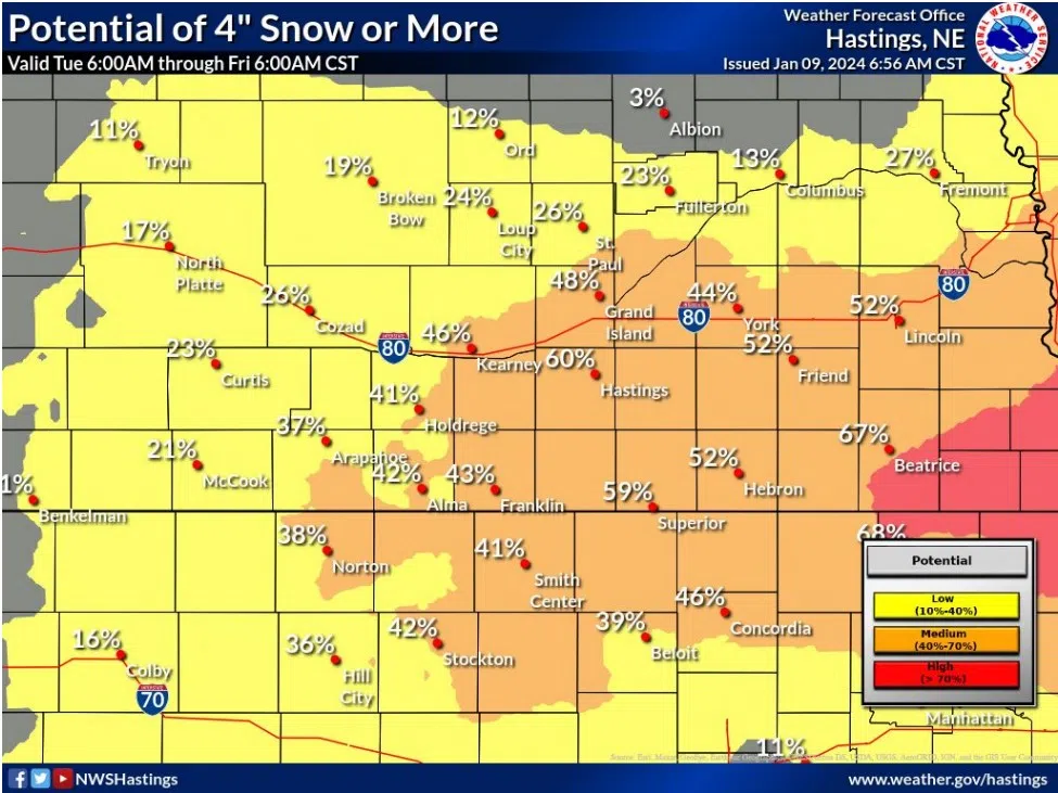
NWS Hastings, Courtesy
HASTINGS — A one-two punch of winter weather is on its way to central Nebraska.
As the area is digging itself out after Monday’s storm, the National Weather Service – Hastings is warning of accumulating snow on Thursday, Jan. 11.
NWS Hastings notes that most areas will see around one to two inches of snow, but bands of three to five inches are not out of the question. The main impacts look to be along and south of Interstate 80 and east of Highway 281.
The main time for accumulating snow looks to be Thursday afternoon around 3 p.m., staring out west, until around 3 a.m. Friday morning.
The wind will not be as strong as with the last system, but they could be strong enough to cause some issues. North winds will gust to 35 mph overnight on Thursday.
The lighter snow combined with strong winds could lead to blowing and drifting snow and poor visibility for those traveling. The worst conditions look to be Thursday evening when the snowfall reaches its peak, per NWS Hastings.
The wind will likely cause issues in rural areas with widespread drifting. The winds will diminish somewhat on Friday but won’t die down fully.
“Anticipate travel impacts Thursday night with the wind and snow. Depending on where the snow band lands, some spots could see some lousy driving conditions Thursday evening,” NWS Hastings states, “Anticipate impacts to the Friday schedule. There will be some rural schools who will have busing issues due to blowing and drifting snow.”
A frigid airmass will follow on the heels of this storm system, the actual air temperature may not reach above zero over the weekend. Wind chills on Friday and Saturday morning could be -20 degrees.
The deep cold will last Friday through Monday, with only minor warming following.