
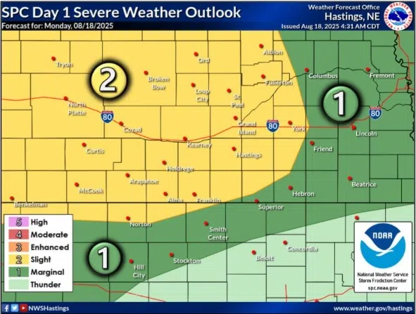
Slight Risk for severe weather across central Nebraska during the evening of Monday, Aug. 18, (NWS Hastings, Courtesy)
HASTINGS — There is a Slight Risk for severe weather across much of central Nebraska during the evening and overnight hours of Monday, Aug. 18.
The Storm Prediction Center has issued the Slight Risk, a two out of five, across much of western and central Nebraska, mainly for the threat of severe winds and quarter sized hail.
According to the SPC, scattered thunderstorms should develop this afternoon over the foothills of central and eastern Colorado, more isolated storms should also form across western Nebraska.
Storms will tend to grow upscale this evening across portions of the Sandhills into southwest Nebraska as they move eastward, according to the National Weather Service – North Platte.
The risk for central Nebraska is that these storms will persist into the evening hours and will track through the region before weakening.
If the storm complex can track through the area, 60 mph wind gusts and hail will be possible with the strongest parts of the storm, according to the National Weather Service – Hastings.
Behind this system, marginally cooler air will push into the area by Tuesday afternoon but won’t make much of a difference as the heat index values could still reach over 100 degrees.