Editor’s Note: My name is Brian Neben and this is my sixth year as storm spotter and chaser. I write a personal column about each outing, as it helps to collect my thoughts and I have felt like people enjoy reading about a rather niche hobby.
BUFFALO CO. — Got my first technical storm chase of the 2024 season on Saturday April 6 and this one truly put “chase” in the title.
These early season chases are always a good chance to blow out the cobwebs and test out teething issues.
I had attempted to chase in southwest Kansas on Palm Sunday, but a lack of quality moisture ensured that I drove 30 minutes away from the Oklahoma border for gas only. At least that bad of a bust came early in the season and I could shake it off easier.
But this has been a leitmotif of these early 2024 chases, almost textbook synoptic setups for severe weather, only to be undercut by minimal dewpoints. Moisture essentially provides the fuel for thunderstorms and the March 24 and April 6 setups were running on essentially fumes.
The chance for severe weather was well advertised for Saturday, April 6, a potent trough of low pressure would be entering the Great Plains and a surface area of low pressure would form in eastern Colorado before moving into Nebraska and Kansas.
The forcing looked to be strong enough to trigger a line of thunderstorms on the edge of the dryline all the way from the Sandhills to southern Kansas.
The only downside to this strong forcing was the fact that storm motions were going to be in the 50 mph or higher range.
Given that my home in south central Nebraska was essentially where the line of storms would begin to mature, I didn’t have to travel anywhere, given that I was in the target area already.
As we approached mid-afternoon, a band of cumulus clouds began to appear in Kansas and were propagating northward. As advertised, this would be the area where thunderstorms would develop.
I waited at home until 3 p.m., when the entire line of storms to the south gained a severe thunderstorm warning. I left Odessa and headed south, noting the strong winds coming from the south. A High Wind Warning was in effect all day Saturday due to the strong pressure gradient that was forming.
This early in the season, high winds ahead of storms usually means blowing dust and there was plenty of it as I got north of Funk. I was finally able to get my eye on the leading edge of the stronger cells that were heading my way.
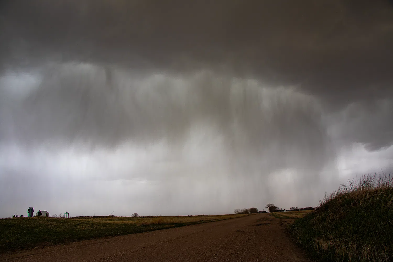
I had to fight with the car door to push it open against the howling winds from the south but I managed and started snapping photos of the rainbands that were falling to my southwest.
There were a few claps of thunder from the storm and for a severe weather enthusiast who hadn’t seen convection in six months, it is always a welcomed sound.
I could only stay in one place for so long before I had to start heading back north. When the storm motion was 55 mph, it felt like chasing a rocketship. I knew my best chance was to simply wait ahead of the storms and then let them run me over, I wasn’t going to keep up with them.
A stronger core of reflectivity was forming northeast of Holdrege and I sped back north on T Road, trying to keep the mass of rain curtains somewhat in view.
However, being closer to this thunderstorm brought even more blinding dust and there were a few moments that visibility dropped to zero. That hampered my progress and by the time I got back to the Highway 30 corridor, the storm was already well out of reach.
I did a little more jogging around in the Platte River valley, trying to put myself in the best position for photos before the storm’s left the area.
The best structure I saw of the day was east of Odessa, where a shelf cloud was emerging out of the west from cells that had already passed through. I only had time to snap enough photos for a panoram before the heavy rain closed in and threatened to drench men.
I drove over to Elm Creek to get a better visual on the backside of the storm on the viaduct over Highway 30, but the clouds were not very well defined. However, looking west, the mass of dust that had been blown into the air seemed to try its best to copy the Dust Bowl.
Overall, this was a short but sweet chase, with the storm motion’s only allowing for a short window where storms would be in the area and somewhat photogenic.
There have been a number of weather systems that have moved through the Plains in the past few months that would have yielded severe weather outbreaks had they occurred in late May. I am curious to see if this pattern continues to hold.
If it does, the High and Southern Plains could be in for a busy spring.